Climate and Geography of El Salvador
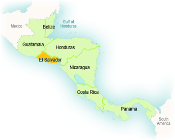
As you can see on the left, El Salvador is in Central America and is between Guatemala and Honduras. It is about 20,721 square km, which is slightly smaller than Massachusetts. Even though it is a really small country, El Salvador has a really nice coastline about 307 km long.
El Salvador is mainly a tropical climate. It has tropical coasts and temperate uplands. From May to October is the rainy season and November to April is the dry season, but the temperature remains the same throughout most of the year.
El Salvador has many frequent volcanic eruptions and earthquakes due to the movement of 3 tectonic plates beneath the Earth's Surface. San Salvador has been destroyed twice by massive earthquakes. Also, San Miguel has had 10 eruptions that affected the city in a negative way. Even though the volcanoes in El Salvador may sound harmful, they have helped by fertilizing the soil and giving an extra energy source.
El Salvador also has many rivers and lakes. Lempa is the largest river in El Salvador of over 300 rivers. The rivers use to be used for transportation and navigation, but it now helps with producing energy from hydroelectric dams. Many of the lakes here have been formed by volcanoes, which made them bordered by steep, green slopes. Lakes in El Salvador aren't used for much more than just pure relaxing.
